
ICW cruisers followed the line for 70 years. 1930s surveyors (top) set the route in Florida.
Goodbye Yellow Brick Road
If you’ve ever followed the Magenta Line down the ICW, you’ll want to know where it’s going next.
Anyone who has taken a trip down the Atlantic Intracoastal Waterway has used the “magenta line” on their paper charts and chartplotters for guidance. Now the providers of e-charts and charting software must face a new reality: The magenta line is obsolete.
The path of the magenta line on our e-charts is taken directly from U.S. government charts, but the National Oceanographic and Atmospheric Administration has begun removing the line from some of its ICW charts and is considering whether to discontinue this feature altogether.
Why? For years experienced boaters have known that the magenta line should be viewed with skepticism as an indicator of depth. But at the same time they appreciated the fact that it provided an easy way to follow the ICW’s route as it winds through the labyrinthine systems of creeks, rivers, and canals that comprise the waterways of the coastal South.
The problem is that some novice boaters have no compunction about speeding down that dotted line like it was the center lane of I-95, and, as NOAA officials recently wrote in their request for comments on the Federal Register, “Numerous examples can be found where the charted Intracoastal Waterway Route (“magenta line”) passes on the wrong side of aids to navigation; crosses shoals, obstructions, shoreline; and falls outside of dredged channels, etc.”
It’s a fact that anyone who follows the magenta line closely enough and far enough will go aground, as I recently demonstrated at a known trouble spot on the ICW at Crooked River in Georgia. The fact that I intended to follow the line until I touched bottom softened the blow (more on that later), but some hard-charger would have experienced the nautical equivalent of a car wreck.
Yet news that the feds are going to take away our magenta line is causing quite a kerfuffle in online boating forums. Knowing its popularity among customers, the two principal suppliers of cartography for chartplotters—C-Map by Jeppesen and Navionics—are retaining the line for now. In other words, as NOAA removes the line on new editions of a chart, C-Map and Navionics will reinsert the line from the most recent NOAA chart on which it appeared, for now.
Meanwhile NOAA has opened the issue for comments on the Federal Register, and one outcome, according to Dawn Forsythe in NOAA’s Office of Coast Survey, might be a decision to resurvey all 1,244 statute miles of the Atlantic ICW—Norfolk to Key West—using crews now tasked with ensuring the accuracy of charts for busy commercial ports. “Maybe we just pull these guys in and have them spend a summer just doing the Intracoastal, or maybe we should go outside and hire someone,” she says.
Ken Cirillo is skeptical. Cirillo, business development executive at Jeppesen, says he doubts NOAA will reorder its priorities, and even if it did, nothing would happen quickly. “NOAA is not going to be in a position to upgrade the recommended route in a short period of time,” he says. “Not going to happen.”
By retaining a “recommended route,” which the government has already declared to be faulty, one would think the cartography companies would be at risk in the event of an accident, but Cirillo contends that they are protected from legal liability by the disclaimers boaters must acknowledge every time they power up a chartplotter or activate PC navigational software or nav apps for tablets and smartphones. Still, he says, C-Map is considering some additional protective language by officially referring to the magenta line as “a very general demarcation of the path of the ICW.”
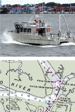
The “best route” on this NOAA chart (above) for the Crooked River in Georgia suggests you cut two red marks and cross a mudbar. A NOAA crew (top) surveys a commercial port, the agency’s top priority.
Cirillo and Navionics Global Product Manager Shaun Ruge agree that crowd-sourcing is the ultimate answer to the obsolescence of the magenta line. Right now there are three major crowdsourcing initiatives in the world of marine navigation.
ActiveCaptain: Founded by entrepreneur and cruiser Jeff Siegel, ActiveCaptain (www.activecaptain.com) relies on a network of cruisers to provide all sorts of useful information, including navigationally significant intelligence about hazards such as what I encountered on the Crooked River in Georgia. It also allows for route sharing. I describe ActiveCaptain as an online cruising guide, but with a huge advantage. The information in a cruising guide is six months old the day it is published; with tens of thousands of members, ActiveCaptain is constantly being updated. ActiveCaptain has been incorporated in C-Map and Garmin cartography and it’s used in PC navigation programs from MaxSea, Nobeltec, Rose Point, and others.
Navionics Freshest Data: This initiative downloads daily updates into multifunction devices either via Wi-Fi or via a PC and storage card, including edits to cartography, new data sets, corrections, Notices to Mariners, and navigationally significant crowdsourced information (including hazards such as shoaling on the Crooked River). Navionics (www.navionics.com) benefits from a huge customer base of users, as it is probably the single most widely used source of cartography for chartplotters on recreational vessels plying U.S. waters.
ARGUS: This demonstration project from a defense-contracting firm called SURVICE Engineering installs black-box hardware on commercial and recreational boats to automatically record chartplotter output while underway. As the opportunity presents itself, headquarters “harvests” the data via a Wi-Fi connection for consolidation into a navigationally useful format. These soundings take into account “static and dynamic factors,” including the state of the tide and the distance of each vessel’s transducer from the surface, and whether the boat is traveling at displacement or planing speeds. This initiative actually received its initial startup funding—a $100,000 grant—from NOAA.
ARGUS is the most scientifically rigorous of the crowdsourcers, although NOAA ultimately decided it was not yet rigorous enough to incorporate into its survey program. ARGUS data showing shallowing depths on the ICW and other waterways can be found on the EarthNC online chart app (www.earthnc.com) and the Salty Southeast Cruisers Net (www.cruisersnet.net), which overlays color-coded depth indicators on ICW charts.
In the case of my Georgia grounding, both ActiveCaptain and Navionics had the answer for the shoaling at Crooked River. Both correctly suggested crossing over an area where the chart showed a sandbar. The crowd was right. There was plenty of water where the chart indicated none, and almost no water beneath the magenta line.
As the marine-electronics industry ponders its next move, NOAA is asking that boaters pay a visit to the Federal Register site at www.federalregister.gov and enter the search term “magenta line” to get to the comment form. The deadline for comments is December 26. There is also a link to some great ICW history. For example:
In 1935, at the height of The Great Depression, NOAA’s predecessor agency received an additional $5.1 million, more than tripling its annual $2.2 million budget. This was a jobs program, and the money was used to hire more than 2,500 new workers, most of whom were to perform field work. Fourteen crews were assigned to what was then called “The Inside Route” from New York to Corpus Christi. The result was essentially the magenta line of today.
Be Heard
Here’s how to make your comment to the government about the magenta line:
- Visit www.federalregister.gov.
- Enter the search term “magenta line.”
- Add your comment before December 26, 2013.
Not a whole lot has been done since. The U.S. has 500,000 square miles of “navigationally significant waters,” 40 percent of which has not been surveyed since 1960.
My initial reaction: Having NOAA redraw the line would be the best possible outcome. Senior Electronics Editor Ben Ellison begs to differ. Ellison, author of the popular marine-electronics blog Panbo.com, says the removal of the magenta line may be the “kick in the butt” that will inspire government and industry to implement a crowdsourcing solution.
With a new generation taking the helm at NOAA, it occurs to me that maybe withdrawing the line is just that, a tactic to jumpstart the next phase in the history of marine cartography—UGC.
User-generated charts, that is.
This article originally appeared in the December 2013 issue of Power & Motoryacht magazine.