


Fear fueled an improbable 1,200-mile journey aboard a scrappy 32-footer on a notoriously dangerous waterway leading to the Arctic Ocean.
No doubt about it, I was nervous. Let’s be honest: I was scared as hell about what lay ahead.
Larry Graf and I were about to embark on a 1,200-mile expedition down the length of Canada’s longest river to the Arctic Ocean. In North America, the Mackenzie, which flows north, is second only to the Mississippi in length. The river is silty, fast, wide and shallow and flows through one of the largest and most remote expanses of wilderness in the world. The poorly-charted Mackenzie is braided and full of islands and sandbars that appear and disappear constantly due to currents, siltation and ice. Rapids aside, it’s dangerous enough to instill fear into even the most seasoned seafarer.

Larry and I had shared boating exploits in Alaska over the years. When he came up with the idea of an expedition down the Mackenzie, I wasn’t immediately interested—I thought it would be senseless, tedious and dangerous. As the months went by, however, Larry kept sharing his research, scary as it was, and came up with a plan. I did my own research and became excited about going along. I’d been adventuring and writing about boats in the Pacific, Atlantic and Caribbean for more than 40 years, but had never tackled a major river. Neither had Larry.
Known throughout the boating industry for embarking on epic expeditions that showcase a new vessel’s prowess and gain publicity, this was perhaps Larry’s most harrowing idea and it was to be in Aspen’s first outboard-powered proa to boot. I’ve known Larry long enough to know that this trip would straddle the line between brave and crazy.
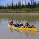


Between late May when the ice melts and early October when it freezes, the Mackenzie is navigable only by shallow draft vessels (i.e. 4 feet). The sparse traffic consists of the occasional tug pushing barges to deliver supplies to remote villages. Each summer, a handful of hardy adventurers spend a month or two paddling portions of the waterway. The only other river traffic are small, open aluminum skiffs with outboards used mainly by locals for hunting and fishing near their villages. Once the ice has melted and winter debris washed downriver, two Canadian Coast Guard buoy tenders survey the river, reposition range markers and re-install buoys removed the previous fall. The timing for removal of the buoys is essential. In 2018, more than 200 were lost because the river iced up before they could be pulled. In our case, in late June when we planned to arrive, it was unlikely the Coast Guard would have fully replaced the buoys: we’d have to navigate sections of the river by sight.
Despite our research, we had no idea what lay ahead. Pleasure vessels simply don’t travel the river. Our two primary guidebooks—both for canoeists—were based on floating the river with a 3-inch draft at a paddling pace. We would draw 31 inches and travel at 20 knots. We’d heard that the mosquitoes, no-see-ums and blackflies could carry off the unsuspecting. We also read about the abundance of grizzly, black and polar bears. Then there was the issue of running aground. If we got into trouble—considering the dearth of vessel traffic—we’d likely be stranded for days or weeks. We took all those factors into consideration and we had extensive backups in place to deal with each concern (including my .303 rifle). Leading up to the trip, I was apprehensive and had trouble sleeping.

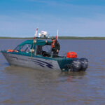
Larry is the founder of Burlington, Washington-based Aspen Power Catamarans. His catamarans, from 28 to 40 feet long are unique in that they are proas, with one hull 35 percent narrower than the other. I have tested a number of Aspen models over the years, finding them to be exceptionally stable, and offering a soft ride and impressive fuel efficiency. It was that fuel efficiency (3 or more mpg at 16 knots) that would give us the range to make this trip possible.
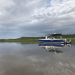
Larry had recently modified his 32-foot model and instead of a single inboard diesel in the starboard hull, he re-engineered it for twin outboards—a 200-hp Yamaha for the starboard hull and a 70-hp Yamaha for the port hull. That combination provided the balance, performance and redundancy he was aiming for. Previous Aspen models feature an enclosed cabin with all the amenities, including a king size bed forward between the hulls. However, ours was the prototype for a warm-weather open model with a center console with bimini top and radar arch. A galley/seat module was specially designed and fitted aft of the two helm seats. A sunken head compartment was accessed via a hinged set of steps. Accommodations consisted of two single settees/berths running aft from the chain locker. A low-slung canvas bow cover was designed to keep us dry and protected from bugs and adverse weather. As an open boat, our sleeping arrangements and cooking facilities were closer to camping than yachting.

Our plan was to trailer the boat, named Arctic Adventure, from Burlington 1,200 miles through British Columbia, Alberta and the Northwest Territories of Canada to Hay River on Great Slave Lake (the fifth largest lake in North America). Then we’d say our prayers and head down the river for eight to 10 days. If we made it to the Arctic, then I’d fly home and Larry would find a way to either have the truck and trailer driven to Inuvik or head back upriver with the boat.
After two nights and three days on the road, we arrived in Hay River where we were greeted by a storm with winds gusting 50 knots. Our first glimpse of Great Slave Lake revealed it to be a seething mess of short, steep and muddy breaking waves as far as we could see. We’d originally planned to cross it to get to the mouth of the Mackenzie. Locals told us that it would be a couple of days before things settled down and anyone could venture out.
In the morning, Larry came up with Plan B—to launch at the small community of Ft. Providence, located where the river proper begins. The two-hour roundabout drive saved us from having to cross 30 miles of storm-tossed Great Slave Lake. The wind was still blustery, about 25 knots, when we crossed the only permanent bridge across the Mackenzie (ice roads are built in the winter) and gazed down at the mile-and-a-half-wide, swirling, muddy and whitecap-streaked river. Seeing the river for the first time, my anxiety only increased. What had I gotten myself into? It was too late to bail.


After fueling up and fielding questions from curious locals, we launched and loaded our gear. In late afternoon we cast off. Finally, all the planning and preparation was over—now we had to buck up and face the river. The beginning did not bode well. We came close to running aground twice within the first 15 minutes and had to use almost full throttle to back up and then find a deeper channel. How would we survive the next 1,200 miles?
Other than brief stops for fuel, we wouldn’t stop each day until late in the evening. We were now in the Land of the Midnight Sun. Tension over the many potential dangers was constant, never allowing us to relax.

Learning the River
The Mackenzie, in total, is 2,635 miles long. It is almost 5 miles wide in places. We regularly found ourselves slicing through a short, steep chop of 2 to 4 feet with 45 to 50 knots of wind in our faces. Sudden blasts of strong wind, much like williwaws, would kick up ominous clouds of sand and spray 60 feet high and a half-mile long. The current was constant, powerful and dangerous—between 3.5 and 8 knots. Often, the can buoys would be half-submerged, trailing long, frothy wakes in the current. To slam into one would be disastrous. The silty water made it impossible to determine depth, so we relied on the depth sounder, which had to be watched every minute. There was good reason for those knots in our stomachs.
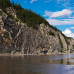
Many times, while we were speeding along at 20 knots through a supposedly deep section of river, we’d see slightly darker water directly ahead and suddenly realize it wasn’t a shadow from a cloud, but a sandbar breaking the surface. In other places a stranded log would be the only indicator. While sandbars are created each year, we also saw long-established islands disappearing, evidenced by toppled trees leaning into the river from steep mud banks. The river is constantly changing and creating new obstacles.

Navigation Nightmare
There are no electronic navigation charts for the Mackenzie. We had to rely on 26 paper charts and our Garmin 1242 chartplotter fitted with the only chip even close—a 2012, satellite-based topographical image of the river. Prior to leaving, the paper charts were laboriously cut and taped together (104 feet in total), attached at each end to rollers, then fitted into a specially designed box that would allow us to “roll” through them as we progressed. This same system is used by the Coast Guard and tug and barge companies.
The paper charts showed the location of buoys from previous years, but we were warned not to trust them as the river changes significantly from year to year. In places, our GPS would show the river up to 2 miles from its charted position. The electronic topo image was useful, but we constantly found ourselves traveling over islands that no longer existed or dodging islands that weren’t shown.
It took our full concentration to monitor depth, locate distant red and green buoys and range markers (the ones that weren’t decommissioned) and to find the best route though unmarked shallows. Sometimes my guess would be right; sometimes Larry’s would. The bottom was frequently less than 8 feet and, in many places, as little as 3 or 4 feet. We developed a process where Larry would drive and I’d stand behind and work the chart table, shouting steering instructions over the noise of the wind and the outboards. Here we were at the top of the world, in total wilderness. It would be incredibly easy to make the wrong choice and end up stranded. Only occasionally did we encounter stretches where we could stay in mid channel and take a breath.
VIDEO: Aspen’s Outboard-Powered Proa
Capt. Bill Pike caught up with Larry and his prototype proa at the 2018 Ft. Lauderdale Boat Show:
The middle section of the river was the toughest. Due to poorly anchored buoys in the sand and mud, we estimated 20 percent were missing. To confuse matters, we realized (after some very close calls) that about 25 percent had been dragged out of position by either the current or logs, and we had to guess whether to trust them or not. A number of times, we simply ran out of buoys and had to guess our way, essentially blindfolded. When the depth got to less than about 6 feet, we’d quickly shift into reverse, sometimes at full throttle, to counter the current, then backtrack to search out deeper water. It was like running a slalom ski course but having to stop suddenly every time the snow disappeared. This was by far the hardest navigation—and blind luck guesstimating—either of us had ever experienced.
On a trip such as this, one realizes just how insignificant humans are in the Northwest Territories. The entire population is about 45,000 souls covering a landmass greater than Texas and California combined. Because of the annual freeze and changing river levels, there are no docks or marinas. Typically, a road leads down to a beach area where the local tin boats are pulled up. Multiple times we beached our boat. We’d drive the bow gently ashore and then deploy our telescoping ladder. We’d carry an anchor ashore and try to find a big rock or a place to dig it in to hold us in place. However, with the wind and current typically running parallel to the beach, it was not the most comfortable situation, so we mostly tried to find shelter behind sandbars or in the few deep river mouths.
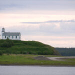
The average populations of the small, isolated villages we encountered—often a hundred or more miles apart—were between 60 and 300. The band office was the focal point and there was no evidence of businesses or industry, other than the requisite Northern Store (which evolved from the old fur trading posts) with its essential goods. Each community was dominated by an aging white-painted church with a prominent steeple. The majority of the homes were unremarkable, but obviously capable of handling the long, cold winters. Despite the hard living conditions, we only experienced generosity and curiosity (and help refueling) from everyone we met. We found the same kindness in the larger communities of Fort Simpson, Norman Wells and Inuvik, which boasted large department stores, hotels and areas with modern homes. We were the talk of the town in each place we stopped. A sleek, 34-foot cruising yacht was unheard of and everyone wanted to know what we were all about.

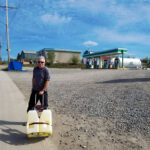
Obtaining gas in this remote part of the world was essential. We carried a total of 175 gallons in the main tanks and in 10, 5-gallon jerry cans. This gave us a range of about 350 miles, based on a conservative 2 mpg, with reserve. However, we were never certain whether gas would be available, and it was often hundreds of miles between villages, so we stopped to top up (using jerry cans or the occasional fuel truck) wherever we could.
We arrived in Inuvik (population 3,400) on our seventh day. From here we would set out on the final 90-mile run through the Mackenzie Delta (an insane maze of shallow channels) to the Arctic Ocean. As warned, the Coast Guard had not yet placed cans in this section of river. We seriously debated ending the expedition here for safety reasons. Fate intervened when the owner of an adventure tourism company supplied us with a screenshot of his track to the ocean overlaid on a Google Earth satellite map. The track was helpful, though we did have to work around some of the shallowest shoals of the trip. Overall, the run to the ocean was delightfully incident-free.
After eight long days on the seemingly endless river, we passed the northern limit of trees where the flat, featureless tundra took over, and reached the Arctic Ocean. It was a joyful, even tearful moment. Following our track back to Inuvik would be a snap thanks to Garmin’s “Follow Route” function. We drifted around under sunny skies and calm waters, thrilled at being able to gaze out at the vast expanse of ocean.
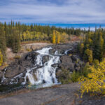
We had no clear idea of what to expect before the voyage. It was like stepping into space. We’d navigated 1,200 miles through incredibly difficult waters and cruised through endless stretches of wilderness. About 200 of those miles were stunningly beautiful while the rest were more of the same low-lying shrub and treed shoreline. The expected encounters with swarms of flesh-eating flies and bears never materialized. It was hard to believe that we’d overcome all the unknowns without serious mishap. I couldn’t imagine a better captain or companion than Larry. Although we faced extreme navigation challenges along the way, credit is due to the captains and crew of the two Coast Guard buoy tenders, Eckaloo and Dumit who gave us advice and who are faced with the impossible task of surveying, placing, maintaining and removing more than 700 can buoys along the river each year.
Would I do it again? No, thank you. My knuckles are still white.
This article originally appeared in Outboard magazine.


