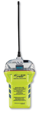
Advertisement

Navigation

ACR GlobalFix iPro

Courtesy of ACR ACR GlobalFix iProACR’s new iPro GPS EPIRB earns its “next generation” marketing tag on three counts, the most obvious one being the reassuring and useful info shown on its one-inch digital display. When you self-test the unit, the screen delivers the results and even

Bushnell ONIX 400

Bushnell ONIX 400Bushnell’s Onix 400 mapping GPS is designed primarily for hikers, but I’m not the only boater to notice its ability to deliver both XM Satellite Weather and Radio in a form portable enough to also go on the water, in the car, etc. Unfortunately the weather data it displays is a limited subset of what’s available

Furuno DRS4A UHD Radar

Furuno DRS4A UHD RadarThere’s so much sizzle to Furuno’s Time Zero plotting innovation, that extraordinary peripherals like its new Ultra High Definition radar and the SC-30 super sensor, are overshadowed. But they sure make themselves known on the

Time Zero, Live

MaxSea’s Iker and Brice Pryzo demo the Time Zero software they developed with Furuno.”You must see it on water, where the technology and boat come together as one; it’s so real!” exclaimed Brice Pryzo, his long arms flailing to overcome his strong French accent and mime the magnificence of his Time Zero navigation software. We

Furuno SC-30 Satellite Compass

Furuno SC-30 Satellite CompassFuruno’s new SC-30 can sense a boat’s sea motion (pitch, roll, and heave) and relationship to Earth—i.e. position, heading, COG, SOG, and ROT (rate of turn). And it feels all that with astonishing accuracy and speed, as I witnessed at least in part (see “

Pocket Navigation

If Mae West were alive, her famously bawdy trademark line might go like this: “Hello there, sailor. Is that a WAAS GPS AIO PND loaded with a continent’s worth of nautical, street, topo, and photo cartography and several hundred thousand POIs in your pocket…or are you just happy to see me?” To which a sorry geek like me might squeak back, “Pardon, Ms. West, no time for flirting; I’ve got gadgets

Jeppesen Marine Nobeltec Max Pro

Jeppesen Marine Nobeltec Max ProWhen Jeppesen Marine took C-Map under its wing early last year, a much-anticipated consequence was the melding of Nobeltec navigation software (NSS) with C-Map’s top-of-the-line Max Pro cartography. They’re here and forever memorialized in new product names VNS Max Pro and Admiral Max Pro, priced

Navionics HotMaps Explorer

Navionics HotMaps ExplorerIf you’ve ever taken a plotter—handheld or otherwise—onto lakes, you probably know how inconsistent (sometimes nonexistent) freshwater mapping is. And you shouldn’t hesitate to try HotMaps Explorer, a $20 teaser product consisting of Fugawi’s full-featured PC planning program along with

Real-World AIS

Recent reports about the 25-foot sailboat Ouzo being run down in the English Channel by the P&O ferry Pride of Bilbao highlight the fact that we pleasureboat operators have to see the big guys because they are probably not going to see us. But what happens in rain squalls and big seas when a ship may be blocked from your view?

Raymarine SmartPilot X Series

Raymarine SmartPilot X SeriesRaymarine is refreshing its entire autopilot line into the SmartPilot X (SPX) Series. All SPX course computers include rate gyros for better performance and use SeaTalkNG (a.k.a. STng or NMEA 2000) interfacing for easier installation and sensor sharing. The primary ST70 control head matches the nifty

FLIR Voyager

Flir VoyagerFLIR has added active stabilization to its $74,999 Voyager camera, but what’s truly noteworthy is its integrated use of dual thermal cameras. Each has only 320×240 pixels of resolution and lacks optical zoom—typical for thermal cams of this class, most of which are FLIR-built anyway—but one has a 20-degree

Managing the Waterway: Electronic Charts 2008

Managing The Waterway: Electronic Charts 2008It may be an Intracoastal Waterway guide publisher, but the name Managing the Waterway doesn’t do this company justice. Neither does the product title Electronic Charts 2008, even though this two-DVD set contains every single digital chart—more than 3,000—currently put out

Standard Horizon HX850S

Standard Horizon HX850SCredit due: Uniden built the first handheld combination GPS/ VHF, but the Mystic was quite bulky and expensive and is now out of production. Standard Horizon’s HX850S hopefully represents the first of a new, much more practical combo generation (at least Lowrance has another in the works). With a body about

Simrad NX40/45

Simrad NX40/45Simrad is refreshing almost its entire product lineup in 2008. The major themes are the extended use of SimNet (a.k.a. NMEA 2000) and the “Simradization” of multifunction display technologies proven by other members of Navico’s “family of brands.” The $2,450 NX40 and $2,950 45 single-station MFDs closely resemble

Navionics Platinum+

Navionics Platinum+As the ever-so-slight name change implies, “plus” is only an incremental change from the original multifaceted Platinum format, mainly offering improved resolution of the photo maps and panoramic port photos. But the improvement is major. One measure of how much more data is included in Platinum+ is that the

acr-globalfix-main.jpg promo image

ACR GlobalFix iPro

Courtesy of ACR ACR GlobalFix iProACR’s new iPro GPS EPIRB earns its “next generation” marketing tag on three counts, the most obvious one being the reassuring and useful info shown on its one-inch digital display. When you self-test the unit, the screen delivers the results and even

bushnell-onix-400-main.jpg promo image

Bushnell ONIX 400

Bushnell ONIX 400Bushnell’s Onix 400 mapping GPS is designed primarily for hikers, but I’m not the only boater to notice its ability to deliver both XM Satellite Weather and Radio in a form portable enough to also go on the water, in the car, etc. Unfortunately the weather data it displays is a limited subset of what’s available

furuno-drs4a-uhd-radar-main.jpg promo image

Furuno DRS4A UHD Radar

Furuno DRS4A UHD RadarThere’s so much sizzle to Furuno’s Time Zero plotting innovation, that extraordinary peripherals like its new Ultra High Definition radar and the SC-30 super sensor, are overshadowed. But they sure make themselves known on the

furuno-navnet-3d-main.jpg promo image

Time Zero, Live

MaxSea’s Iker and Brice Pryzo demo the Time Zero software they developed with Furuno.”You must see it on water, where the technology and boat come together as one; it’s so real!” exclaimed Brice Pryzo, his long arms flailing to overcome his strong French accent and mime the magnificence of his Time Zero navigation software. We

furuno-sc-30-satellite-compass-main.jpg promo image

Furuno SC-30 Satellite Compass

Furuno SC-30 Satellite CompassFuruno’s new SC-30 can sense a boat’s sea motion (pitch, roll, and heave) and relationship to Earth—i.e. position, heading, COG, SOG, and ROT (rate of turn). And it feels all that with astonishing accuracy and speed, as I witnessed at least in part (see “

pocket-navigation-main.jpg promo image

Pocket Navigation

If Mae West were alive, her famously bawdy trademark line might go like this: “Hello there, sailor. Is that a WAAS GPS AIO PND loaded with a continent’s worth of nautical, street, topo, and photo cartography and several hundred thousand POIs in your pocket…or are you just happy to see me?” To which a sorry geek like me might squeak back, “Pardon, Ms. West, no time for flirting; I’ve got gadgets

jeppesen-marine-nobeltec-max-pro-main.jpg promo image

Jeppesen Marine Nobeltec Max Pro

Jeppesen Marine Nobeltec Max ProWhen Jeppesen Marine took C-Map under its wing early last year, a much-anticipated consequence was the melding of Nobeltec navigation software (NSS) with C-Map’s top-of-the-line Max Pro cartography. They’re here and forever memorialized in new product names VNS Max Pro and Admiral Max Pro, priced

navionics-hotmaps-explorer-main.jpg promo image

Navionics HotMaps Explorer

Navionics HotMaps ExplorerIf you’ve ever taken a plotter—handheld or otherwise—onto lakes, you probably know how inconsistent (sometimes nonexistent) freshwater mapping is. And you shouldn’t hesitate to try HotMaps Explorer, a $20 teaser product consisting of Fugawi’s full-featured PC planning program along with

real-world-ais-main.jpg promo image

Real-World AIS

Recent reports about the 25-foot sailboat Ouzo being run down in the English Channel by the P&O ferry Pride of Bilbao highlight the fact that we pleasureboat operators have to see the big guys because they are probably not going to see us. But what happens in rain squalls and big seas when a ship may be blocked from your view?

raymarine-smartpilot-x-series-main.jpg promo image

Raymarine SmartPilot X Series

Raymarine SmartPilot X SeriesRaymarine is refreshing its entire autopilot line into the SmartPilot X (SPX) Series. All SPX course computers include rate gyros for better performance and use SeaTalkNG (a.k.a. STng or NMEA 2000) interfacing for easier installation and sensor sharing. The primary ST70 control head matches the nifty

flir-voyager-main.jpg promo image

FLIR Voyager

Flir VoyagerFLIR has added active stabilization to its $74,999 Voyager camera, but what’s truly noteworthy is its integrated use of dual thermal cameras. Each has only 320×240 pixels of resolution and lacks optical zoom—typical for thermal cams of this class, most of which are FLIR-built anyway—but one has a 20-degree

managing-the-waterway-electronic-charts-main.jpg promo image

Managing the Waterway: Electronic Charts 2008

Managing The Waterway: Electronic Charts 2008It may be an Intracoastal Waterway guide publisher, but the name Managing the Waterway doesn’t do this company justice. Neither does the product title Electronic Charts 2008, even though this two-DVD set contains every single digital chart—more than 3,000—currently put out

standard-horizon-hx850s-main.jpg promo image

Standard Horizon HX850S

Standard Horizon HX850SCredit due: Uniden built the first handheld combination GPS/ VHF, but the Mystic was quite bulky and expensive and is now out of production. Standard Horizon’s HX850S hopefully represents the first of a new, much more practical combo generation (at least Lowrance has another in the works). With a body about

simrad-nx4045-main.jpg promo image

Simrad NX40/45

Simrad NX40/45Simrad is refreshing almost its entire product lineup in 2008. The major themes are the extended use of SimNet (a.k.a. NMEA 2000) and the “Simradization” of multifunction display technologies proven by other members of Navico’s “family of brands.” The $2,450 NX40 and $2,950 45 single-station MFDs closely resemble

navionics-platinum-plus-main.jpg promo image

Navionics Platinum+

Navionics Platinum+As the ever-so-slight name change implies, “plus” is only an incremental change from the original multifaceted Platinum format, mainly offering improved resolution of the photo maps and panoramic port photos. But the improvement is major. One measure of how much more data is included in Platinum+ is that the

Advertisement
Advertisement
PMY_WHITE_logo